Anglo-Saxon Romsey
The Evidence in the Landscape
Anglo-Saxon Land Use
A Very Large Jigsaw Puzzle
Attempting to understand the development of Romsey during the Anglo-Saxon period involves piecing together the evidence from a variety of sources. In a study based on landscape analysis the information can be added to a map, combining topography and geology, historical maps and charter landmarks. Viewing Romsey within the wider landscape helps to explain how the settlement supported itself and how it fitted into Saxon Wessex.

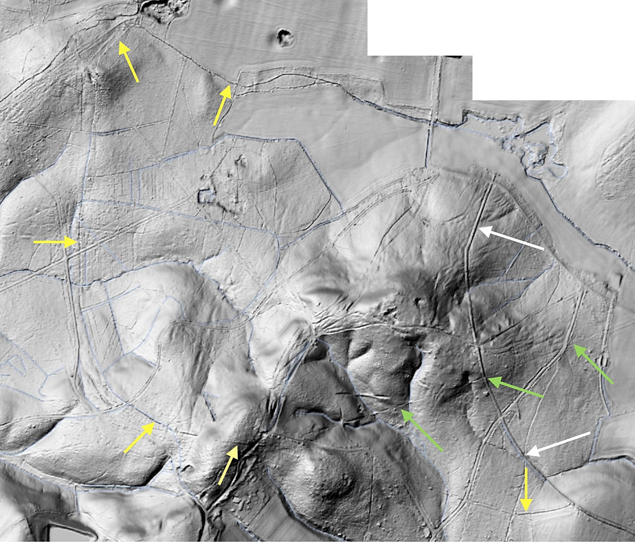
LiDAR base map with surface water. A detail of the 1845 tithe map shows the location of the town. Symbols represent land use: arable on the river terrace; the cattle enclosure at Ashfield; a horse stud at North Baddesley; a deer park at Ampfield; and the site of a signalling beacon on Toot Hill. Two additional red arrows point to a military road, Stemn’s path that provided access to the ‘lookout’ hill.
LiDAR provides a useful background for building up a picture of land use. It is particularly relevant for a study of Saxon Romsey. Here the topography was an important factor in the choice of a site for the early religious community, on a river terrace overlooking the floodplain. This lowest terrace shows up clearly in the LiDAR, with a highlight at its western edge and earlier terraces rising to a plateau to the east. The brickearth topping the terrace provided an easily-worked, well-drained and fertile soil, ideal for arable farming. The terrace south of the town has never been built on. Field banks show up in the LiDAR alongside the old road heading south towards Southampton.
Cattle were essential to a farming economy. Oxen pulled the ploughs to grow the crops and the carts to carry it from the fields. Evidence for stock raising is visible in the landscape. ‘Oval’ enclosures were probably used mainly for over-wintering the breeding herd and plough oxen. They are often associated with a nearby area of stream-side pasture suitable for cows and their calves and used for dairying. The place-name wic seems to refer to this seasonal activity. An enclosure at Ashfield, south of Romsey, can be seen on the 1787 map of the Broadlands Estate and the 1845 tithe map. The North Baddesley estate map of 1826 shows a less well defined enclosure of a similar size.

Detail of the 1787 Broadlands Estate map centred on the Ashfield oval enclosure. A curved perimeter efficiently enclosed a maximum area with the minimum length of stock-proof boundary. The drawing was aligned to fit the sheet of paper, rotated 29 degrees clockwise from north.

The Ashfield enclosure on the 1845 Romsey tithe map, on LiDAR base map. The small stream running through the centre would have supplied drinking water for the cattle during the wetter winter months.

Arrows point to the Ashfield oval to the left of the map. Curved boundaries on the 1826 North Baddesley estate map appear to define another enclosure of a similar size. This probable enclosure was identified while working with North Baddesley local historian Jane Powell on the solution of the North Stoneham charter. The cattle enclosures are likely to be early features in the landscape. A cattle bone from an excavation in Romsey has been radiocarbon dated to the 7th century.

Google Maps/Google Earth view of the changing landscape south of Romsey. A new housing development is underway on the western edge of North Baddesley, along Hoe Lane. Planning approval was granted in January, 2025 for the building of houses on the site of the tyre dump within the Ashfield stock enclosure.

A road labelled Dirty Drove, left arrow, heads towards the enclosure from the west. Another roads heads north to Zion Hill Farm on the southern edge of the semicircular enclosure boundary

North Stoneham shares a boundary with Chilworth, shown here on the 1755 estate map. The arrow points to a section of the boundary described in the charter of 932. The boundary circuit was heading north at this point on Byrewege, on Byre Way. The word byre meant the same thing in Old English as it does now, a cowshed or cattle shelter. The North Stoneham boundary turned east when it reached Cytanbroces aelwilme, the spring of Kites Brook, a name that survived as Kites Oak Copse on the North Baddesley estate map. Presumably the Byre Way continued north to the cattle enclosure.
The Anglo-Saxons didn’t use horses as draught animals - oxen served in that role - but they would have used packhorses to carry goods. Horses would have been able to manage rough terrain unsuitable for carts or wagons. One of the landmarks on the Michelmersh charter of 985 was the horseweges heale, the corner of the horse way. At this point the boundary meets the road heading towards Farley, a steep uphill climb. The name suggests it was suitable only for horse transport. The horse on the maps above shows the location of stodleage, stud lea, on the 909 Chilcomb charter. Horses raised at the stud could have grazed the wood pasture - the lea - or on the adjacent grassland, now Baddesley Common.

A compilation of historical maps superimposed on LiDAR hillshade. Left - 1845 Romsey tithe map showing land use. Lower centre - 1755 Chilworth estate map. Centre right - 1826 Baddesley estate map. Top right corner and centre top - outline version of 1588 Hursley estate map, redrawn by Roger Harris. The estates surround Baddesley Common in the centre of the image.
Pasture would have been an essential resource for raising livestock. The Chilcomb charter of 909 proceeds from stud lea to ticnes felda and the Ampfield charter, written sometime between 909 and 924, starts and ends at ticcenesfelda wicum, on the southern edge of the deer park. A feld was an area of open land - Ticcenesfeld must have been the name for, at least part of, Baddesley Common. The wording of the Chilcomb charter doesn’t define the line of the boundary as it crossed the feld. An open, unfenced grassland could have been shared by the surrounding estates through an allocation of grazing rights for a specified number of animals.

3D map showing the land described in the Ticcenesfeld/Ampfield charter. The Bishop’s Bank forms the western boundary. The green arrow points to the probable location of the holding stow. Most of the land is on a bedrock geology of London Clay and would have been largely woodland in the 10th century, as it was when the 19th century OS map was drawn.
A charter granting land at Crawley by Edward the Elder to Winchester Cathedral included the bounds of an additional piece of land at Ampfield. The boundary description starts by heading north from Ticcenesfelda wicum along a haga, the Bishop’s Bank, and returns to the start along a haga. The enclosure of at least part of the area by a haga, a bank topped by a hedge or fence, suggests that this was a deer park. The holding stow was a landmark on the eastern boundary. Stow means place and a hold was a corpse. A ‘corpsing place’ makes sense in the context of a deer park - the location where the deer carcasses were processed following a hunt.

Detail of the 1588 estate map by Ralph Treswell showing a deer park at Hursley. North is to the right. Ampfield was part of the Hursley estate. Like its Saxon predecessor, the deer park on the 16th century map is wooded and crossed by a stream. The deer are contained within the park paling, a fence built along the top of a bank. The boundary bank, with its inner ditch, has survived for much of its length. Sections are scheduled by Historic England.

The deer park on a copy of Ralph Treswell’s 1588 map of the Hursley estate, with modern surface water, viewed in 3D. The park pale runs along the edge of a drove road at the southern end of the deer park, suggesting that the road predates the park which was created in the 12th century. The drove road with its characteristic funnel opens on to the grazing land of Ampfield and Baddesley Commons, lower left.

The outline version of the 1588 Hursley estate map with surface water and modern roads added. The A3090 is shown in red, running along the Straight Mile to Ampfield then east and north around the medieval deer park of Merdon Castle and through the village of Hursley.

Plan of Merdon Castle and Hursley Park by OGS Crawford, Archaeology in the Field, p195. The banks are visible on the 1588 Hursley estate map.

The park pale on an outline version of the 1588 Hursley estate map overlaid on a 3D LiDAR hillshade image.

This composite 3D LiDAR image shows features surviving under Ampfield Wood. The height has been exaggerated - the hills are less steep than they appear. The curving pale of the Hursley deer park is on the right. The Portland Bank, which OGS Crawford traced on the ground, is visible for most of its length. The ridge of high ground at the centre is cut by traffic ruts, some continuing through the pale and into the park. The 1588 Treswell map shows a gate near the location of the tracks heading east off the ridge; tracks leaving the ridge to the north appear to pass under the pale. It is unlikely that these tracks, created as people and livestock shifted paths to avoid obstructions and muddy puddles, would have developed in woodland. The landscape must have been more open at the time they formed.

The Hursley deer park and outer enclosure mapped with LiDAR hillshade and modern surface water. The outline drawing is somewhat out of alignment with the features on the ground. The curved line at the southeast corner of the outer park bounded the trackway visible in the LiDAR on its west and north sides.

This copy of the 1588 Treswell map, drawn by Roger Harris, shows a road leading to a gate in the Portland Bank. The LiDAR trackway follows the curved line to another gate through the park pale.

The 1588 map shows the funnelled entrances to the roads leading from Anvile (Ampfield) Common. The funnels aided the movement of livestock from the grazing land.
The boundary of the Out Park enclosure, yellow arrows, is visible in the LiDAR for most of its length, extending from a well preserved section of the Park Pale, white arrows. A trackway, marked in green, crosses the pale and runs towards Hawker’s (Hauckers) Hill. It follows a straight course over difficult terrain. The sloping ground has been cut back and levelled and the gullies draining the higher ground have been bridged to carry the track.

The straight trackway with Hawker’s Hill on the left. The section of the track west of the park pale measures 550m.

Profile of the line taken by the straight track.
The straight trackway appears on the first edition OS map, surveyed in the mid-19th century, heading west across Hursley Park from Southampton Lodge and into Ampfield Wood. It survives as a public footpath.


The western side of Hawker’s Hill appears to have been extensively quarried. A series of shallow pits extend along the side of the hill north of the Portland Bank for a distance of 115m, brown line. Further pits and scoops lower down the slope can be seen in a side-on view of the hill. The geology here is the Whitecliff Sand Member (see the Geology page) which includes deposits of clay as well as sand. Large pits at the southern end of the hill are clay diggings. The date of the straight trackway is unknown. Was it built as an access road to the quarry? Could it be Roman?

The LiDAR hillshade image shows Merdon Castle at the northern end of a chalk spur within the deer park. The motte and bailey castle was built in the 1130s on the site of a Late Bronze Age or Early Iron Age hill fort. The rectangular field banks laid out along the ridge and the lynchets on the east side predate the castle and deer park and are probably contemporary with the hill fort. Lynchets are terraces formed by ploughing sloping ground.

A 3D LiDAR view of the lynchets east of Merdon Castle. The village of South Lynch is in the valley below Violet Hill, top right.

Adding contour lines to the map shows the slope of the chalk ridge, affording Merdon Castle a distant view to the south.

A view looking south from Merdon Castle drawn by GF Sargent in 1830. The house within the deer park on the 1588 Treswell map was behind the mansion in the picture.

A view of the deer park, complete with a herd of deer, published in 1839. Hursley Park is now owned by IBM.

3D LiDAR hillshade image of the landscape surrounding Hursley Park. Chalk bedrock creates a distinctive landscape, dissected by dry valleys and pock-marked by chalk pits. The geology changes in the lower part of the image where streams flow through the clays, sands and silts at the edge of the Hampshire Basin. The height has been exaggerated to bring the minor, man-made features into view. These include, to the north, a Roman road near an 18th century monument on a mound and several barrows. The outlines of early field banks and the lynchets on the sides of valleys represent the labour of many generations of farmers in what was a heavily utilised landscape.

The Roman road between Winchester and Old Sarum cuts across the landscape. Quarry pits are visible in the LiDAR alongside the road. South of the road at the centre of the image is a Bronze Age bowl barrow. This is likely to have served as the focal point of the Saxon execution site recorded as a boundary landmark in the Chilcomb charter of 909 (see the Charters page). The barrow is a scheduled monument.

Second edition OS map showing the Winchester-Old Sarum Roman road north of the Farley Mount Monument. The Tumulus (barrow) on the right was used as boundary landmark; it appears on the 1588 Treswell map at the northwest corner of the Hursley estate, labelled 'Robin hudes butt'.

Looking north from the west boundary of the Hursley Estate, the Farley Mount Obelisk appears as a white dot on the horizon. The stone obelisk was built on top of an earlier earthwork; a mound made up from the chalk bedrock would also have been visible as a white landmark on the crest of the ridge.
The long-distance view from Farley Mount on Beacon Hill. An Armada beacon was sited on the hill, and it was probably also part of an Anglo-Saxon beacon chain (see the Defence page). The obelisk was built in the 18th century to commemorate a horse named Beware Chalk Pit.

Google Earth maintains a catalogue of satellite and aerial photos taken over past years that can be viewed using the Historical Imagery feature. An enclosure to the west of Farley Mount was visible as a cropmark in December 2005. It is a Scheduled Monument, probably dating from the Iron Age. It is described in detail on the Historic England website.

A side-by-side comparison of the cropmark and LiDAR views of the Beacon Hill enclosure.

Most of the small fields mapped by Ralph Treswell in 1588 have disappeared from the landscape. The houses and fields of the small hamlet of Marden have been replaced by Merdon Farm.
Sparsholt Roman Villa

The outline of an early field system is visible in the LiDAR image, preserved beneath the woodland north of the Winchester to Old Sarum Roman road. The yellow arrow points to the location of Sparsholt Roman villa, lying west of a prominent zigzag field bank in Cow Down Copse.

The second edition OS map shows the line of the Roman road and the position of Sparsholt villa.

The mosaic floor from the principle reception room of the Sparsholt villa is on display in Winchester City Museum. It was excavated in the late 1960s by David Johnston who wrote an article on the villa for Current Archaeology, Issue 12.


David Johnston's plan of his excavations shows the villa buildings arranged around a courtyard. This rectangular courtyard can be seen in the LiDAR.
Parnholt Wood - A Lost Landscaped Park

Woodland covers the chalk landscape west of Farley Mount, shown here on the 2nd edition OS map with contours added in brown. Numerous tracks and paths crisscross through Parnholt Wood, some extending like the spokes of a wheel from a circular feature labelled ‘The Ring’. According to the Hampshire County Council Archaeology and Historic Buildings Record for King's Somborne, this earthwork is a tree-ring documented to at least the 14th century. The record does not mention the radiating paths. A map drawn in 1759 by Isaac Taylor reveals its actual origin - as the central focal point of an extensive landscaped park.

The Ring with its radiating paths is a striking feature in the LiDAR view of the landscape. The LiDAR shows a mound at the centre of The Ring which wasn’t noticed by the OS surveyors. Taylor’s map depicts a building here, perhaps with an observation tower on its roof. Tracks appearing as parallel lines are modern; these probably follow the lines of the paths in the 18th century park. Two further paths appear as faint linear features extending to the southeast from the circular ditch. Northwest of The Ring is a mound known as Dirty Mount, a bowl barrow that was incorporated into the layout of the park.

The red line on the LiDAR indicates the position of the profile cutting through The Ring. Its diameter can be measured on the X axis from the low points at the ditch either side - approximately 170m.

Profile of Dirty Mount. The straight paths leading to the Mount indicate that it was a point of interest within the park. It is thought to be a Bronze Age bowl barrow; it might have been heightened to increase its impact. Mounds or mounts were often constructed as viewing platforms within 18th century gardens.

Profile of Farley Mount. The Farley Monument was probably constructed on the top of a barrow

In 1759 Isaac Taylor produced a map of Hampshire drawn at a scale of about 1 inch to the mile. Much of his surveying work involved the drawing of estate maps, completing over 100 in Dorset. This particular interest and expertise must account for his relatively detailed and accurate drawing of the park at Farley. Buildings are scaled according to their importance - the owner of the park lived in the house southeast of the park.

LiDAR view from the Parnholt Wood park to Farley Mount. The Roman road from Winchester to Old Sarum cuts across the upper right corner to the north of Farley Mount.

The basic layout of the park as shown on the Taylor map is visible in the LiDAR. The two parallel paths that intersect the ring are clear to the south and southwest of the ring. The four wide avenues on the map aren’t apparent in the paths radiating from the ring - the map has exaggerated the principle pathways.

This is a detail of Thomas Milne’s 1 inch map of Hampshire published in 1791. The park at this date sits within Farley Wood. The drawing appears to be quite inaccurate - there are extra paths and the Ring has lost its circular shape. A road from Farley House to The Ring connects the owner to his park and onwards to Kings Somborne

The Hampshire Record Office holds a very large and wonderfully detailed map of the Lands and Tenements in the Manor of Kings Somborne belonging to Paulet St John, drawn by William Godson in 1734 (Finding number 2M37/556). The photos here show details from the map - the map was too large to view as a whole, so it was photographed in sections as it was unrolled. It shows the village of Kings Somborne mapped along with the strips in its open fields. The streets and houses of Little Somborne and Ashley are also on the map and, to the south, Parnholt Wood prior to its transformation into a landscaped park. Accompanying the map is a reference book (Finding Number 36M66/27) describing the open fields and the individual strips. It includes pages for maps of Farley Chamberlayne and Sandey Downs Farme near Stockbridge. These maps are not in the Record Office.

Kings Somborne and its open fields. The properties in the village are labelled with the names of the tenants. The labels in red - a capital letter and number - refer to entries in the map reference book.


Detail view of Kings Somborne. The road from the south is labelled ‘hollow way’ which suggests an ancient road. The churchyard appears to be fenced on the sides facing the roads. The stocks are in the road west of the church.

Paulet St John’s mill is on the western edge of the map.


Kings Somborne mill was located on the Somborne Stream to the west of its confluence with Park Stream, a waterway carrying water from the Test. The map shows the water divided into two channels, one running through the mill to power the mill wheel and the second serving as a bypass channel. The numbered plots were let along with the mill. The map reference book records Mr Reeves as the tenant in 1734.
T1 - Mill house and Garden
T2 - Close joining to the Garden
T3 - Close joining to the Last
T4 - The Meadow
Horsebridge Mill was built in the 19th century on the site of the earlier mill. The mill and mill house are Grade II listed - they are described on the Historic England website.

Horsebridge mill is shown on a 1776 plan of the fisheries of Kings Somborne and North Houghton (HRO 15M50/706). The two river channels leading to the mill are identified as:
A - Horsebridge River
B - Kingsumbourn River
Both watercourses were owned by Paulet St John.


The title of this 1776 plan, the Fishery belonging to the Manors of Kings Somborne and North Houghton, emphasises the value of the Test as a source of fish, including eels and salmon. The water channels coloured blue were owned by Paulet St John and those coloured red by Lord Rivers - George Pitt, 1st Baron Rivers. The land on the Test floodplain was also a valuable resource for grazing and hay. Lord Rivers’ land had been engineered to create water meadows, an irrigation system that encouraged the growth of grass earlier in the spring and increased the hay crop. Water from the Test, labelled A, was diverted into an artificial channel, O the Main Carriage, through the ridges of the water meadows and into Black Lake, N.

On the 2nd edition OS map the channel carrying water from the Test to the water meadows is labelled North Head Carrier. This area of the floodplain lies within John of Gaunt’s Deer Park. Surviving lengths of the park pale are listed monuments. There is a map on the Historic England website.

The water channels and ridges of the water meadows show up clearly in this LiDAR image. A drainage channel runs alongside the western park bank. A section of the east bank is visible on Yew Hill.


The villages of Little Somborne and Ashley on the Godson map.


Godson's map shows a number of lanes and tracks running through Parnholt Wood. The road through Balyes (Baileys) Down is labelled ‘the Road from Romsey to Winchester’. This route would be disrupted when Parnholt Wood was transformed into a landscaped park by Paulet St John a decade or two after this map was drawn.

This image, made up from several photos, shows the location of Parnholt Wood to the south of Kings Somborne.

Parnholt Wood and Farley Mount on Google Earth.


A forestry track runs around the perimeter of Parnholt Ring.
The view from The Ring of the track heading towards Kings Somborne. This track appears on the 1791 Milne map as part of the route connecting Farley House with the village.


Taylor’s 1759 map shows a ladder-like arrangement of tracks intersecting The Ring. Part of this layout survives as field boundaries, shown here looking southwest from The Ring.


Taylor’s map shows a 3-dimensional, side-on view of the most important buildings in Farley. Like many of the churches on the map, Farley church is depicted with three separate components - bell tower, nave and chancel. The house of the owner of the park, to the north of the church, appears half hidden behind the church. The number 441 below the drawing identifies the owner as Paulet St John.

The church of St John, Farley Chamberlayne.

Farley church from the north looking across the site of Farley House.

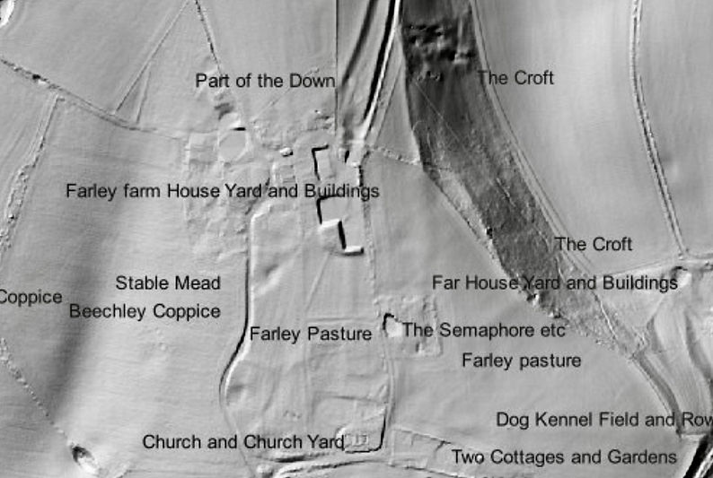
In this LiDAR image, Farley church and churchyard are in the lower right corner of the rectangular enclosure, with the site of Farley House to the north. An oval feature northwest of the churchyard is probably part of the garden.

The oval feature that is faintly visible in the LiDAR shows up clearly as a parch mark in this view from Bing Maps. It measures 40m in length. The parched grass might overlie a paved or gravel walk. Semaphore House sits within a square garden to the east of the site of Farley House. It was built c.1800.

The reference book to the 1734 Godson map includes details of a, now missing, map of Farley Chamberlayne. It includes a description of the buildings and gardens of Paulet St John’s mansion as they were numbered on the map:
1. The house and Court
2. The Court before the house
3. The Church and Church yard
4. Dairy house, Well house and Court
5. Dairy house garden
6. The Pleasure Garden
7. The fruit Garden
8. The orchard
9. The Stables and yard
10. Barne yard, Stables and Barne
11. The Dogg kennel
12. Dogg kennel Garden
13. Garden and Rickyard
The total area was recorded in acres, rods and perches.

By the time the Farley Chamberlayne tithe map was produced in 1838 the mansion north of the church was gone and the site was in use as pasture. The only name to survive from the mansion complex was Dog Kennel Field.

The 1838 tithe map of Farley Chamberlayne labelled with the names of the owners of the fields. At this date, the northern half of the parish was owned by Paulet St John Mildmay, the great grandson of Paulet St John. His father had added Mildmay to his surname in 1790 when he inherited the property of his wife’s great uncle Carew Mildmay. The fields around Slackstead were owned by Thomas Godwin. This part of the parish was a detached portion of Micheldever until the mid 19th century.

1st edition OS map of Farley Chamberlayne and the detached land of Micheldever.

Paulet St John spent the final years of his life in Abbey House with his third wife, Jane. Jane was the widow of William Pescod, the owner of Abbey House in 1750 when it was pictured on William Godson’s map of Winchester. The house originally faced onto the gardens. In his will, written in 1777, Paulet left Jane ‘all the Wine Strong Beer and other Liquors which shall be and remain in our Dwelling House at the Abbey in the City of Winchester at the time of my Decease’. A codicil to the will, added in January 1778, extended this bequest - ‘upon recollection that I have in my House at Farley a much larger Quantity of Wine in my Cellars there my Will and meaning is that my Wine in both Cellars as well as in the Abbey as at Farley shall be equally Divided between my Dear Wife Jane and my Son Sir Henry Paulet St John’. Jane was also to receive ‘such Stores as are in my Houses at Farley and Abbey Vid. Bacon Coffee Teas Chocolate Sugar’. Paulet requested that his son give Jane an annual supply of firewood and ‘such Quantity of Venison and Fish as her Household shall reasonably Require’. The fishery at Kings Somborne would have supplied the fish and, as it was located within the former deer park of John of Gaunt, perhaps it also supplied the venison.

A list of the properties owned by Paulet St John in a copy of his will (HRO 50M63/ B73/73).


Paulet St John, the owner of Farley House and the park in Parnholt Wood, is buried in the church at Farley Chamberlayne.


Paulet St John is less well known than his horse Beware Chalk Pit, buried beneath the monument at Farley Mount.
Open-field Farming in Kings Somborne
The 1734 Godson map of property belonging to Paulet St John in Kings Somborne shows the village surrounded by its open fields. The map and its reference book record the division of the fields into the strips that were allocated to the various farms. The farm houses were located within the village. Some had barns and yards, others gardens or orchards; most had an enclosed field or meadow within the village. Each farm had an allocation of strips for arable farming scattered throughout the seven open fields. The farmers also had grazing rights for a specified number of animals - for sheep in the common fields and ‘Great Beasts’ in the marsh.

This page of the reference book starts with the final entries describing Friends Bargain. The current allocation for grazing livestock is noted, along with an earlier figure - the Old Stent. A stent or stint is a legal entitlement to graze a specified number of animals on commonly owed land. The numbers have been reduced for all of the farms owned by Paulet St John. The section for Bannings Bargain lists the farm house with its associated fields, followed by the strips it holds in the open fields. Each strip is defined by its location relative to adjacent strips, fields or roads. The area of each strip is measured in acres, rods or roods, and perches: 4 rods = 1 acre and 40 perches = 1 rod. The names of the owners of the land abutting the strips help to identify the prominent land owners in Kings Somborne.
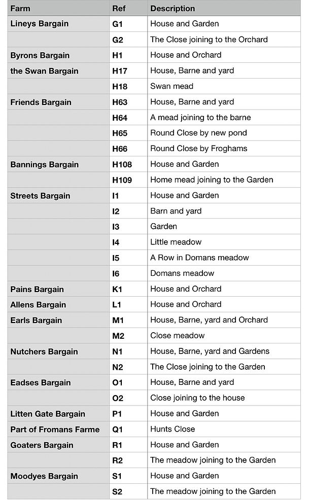


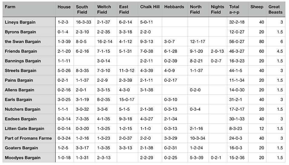

Kings Somborne had seven open fields. Hebbards and Weltch fields were directly north of the village. North field lay between them, with the small Nights field beyond. South field covered the lower ground on the floor of the Somborne valley and the higher ground east of the road to Braishfield. East field extended from the end of the village towards Chalk Hill field. The grey bands with a feathered edge on the map represent ridges or the edges of higher ground.

A comparison of the Godson map with the second edition OS map shows that there was little change in the village between 1734 and the late 19th century.

LiDAR shows the village of Kings Somborne in the bottom of a valley, straddling the Somborne stream. Modern development has spread to the south. The strips of the open fields are invisible. Strip lynchets have survived later ploughing on the sloping ground on the northern side of the valley. The circular pits dotting the landscape are common features on Chalk geology. The Roman road from Winchester to Old Sarum runs along the southern edge of the image. The later roads, eroded into the surface, are useful landmarks for identifying the location of the open fields on the Godson map.

Hebbards field extended to Hew Hill, now called Yew Hill, with Marsh Hill further north. The Drove on the east side of Hebbards led to a gate at the corner of ‘King Sumborne Marsh’, which provided grazing for the farmers’ Great Beasts. Park Lane bordered Hebbards on the west side; the lane ran north from the village alongside ‘Sumborne Park’, John of Gaunt’s Deer Park.
North Field covered a large area, with the blocks of strips aligned on a NE-SW axis. Nights Field and the field boundaries in Marsh Coate Farm followed the same alignment. This pattern suggests that the strips of the open fields had been laid out within an earlier, prehistoric, coaxial field system.
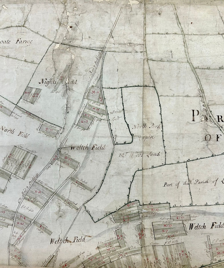
Nights Field was a single, rectangular field located between Marsh Coate Farm and the road to Stockbridge. The blocks of strips drawn on the map in Nights Field and those in Weltch Field on the opposite side of the road are on the same alignment as the field divisions in North Field. Weltch Field covers the area north of the village to the east of the Stockbridge Road, up to the land belonging to the parish of Little Somborne. Strips are on a NW-SE alignment.

LiDAR shows strip lynchets running parallel to the valley on the sloping land north of the village. The grey band on the map crossing Hebbards and Weltch field represents the bank of a strip lynchet. The open-field strips near the village are aligned on the lynchets. A road labelled The Drove heads north from the centre of Kings Somborne. A section of the road is being used for arable. A description of the strip in the reference book says it is bounded on the east by the Drove.

This map shows the approximate positions of Hebbards and North Field relative to the marsh and deer park. The base map is from the National Library of Scotland Maps website. It is late 19th or early 20th century.

The hollow way continued south past Parnholt Wood to Baileys Down. The road crossing South Field and to the west side of the Gleeb Land continued through Eldon into Michelmersh parish and onwards to Romsey.

This shows the eastern end of the village and the roads running through East Field. The rectangular, hedged field called Tanners Mead was on the north side of the Somborne stream. Fields belonging to Ashley parish are on the higher ground between South Field and East Field. East Field is divided into several sections by the roads and the topography.

The long rectangle of Tanners Mead is clearly visible in the DSM (Digital Surface Model) LiDAR on this Side by Side view in NLS Maps.

The road to Winchester heads east through East Field and along the edge of the higher ground of Chalk Hill. Another road branches off towards Ashley. The footway to Ashley further south ignores the strips, cutting straight across them. A road running north from Ashley is labelled Road to Rookley, a manor near Up Somborne.

The road to Winchester follows the valley of the Somborne stream, flanked by the higher ground of Chalk Hill. The road to Rookley cuts diagonally across the strips as it climbs out of the valley; a road heading southeast also crosses strips. The road to Little Somborne is on the boundary of the parish of Crawley.
Read more:
Where Was Ticcenesfelda Wicum?
Further Thoughts on Ticcenesfelda Wicum
An ‘Oval Enclosure’ at Ashfield - Cattle in the Anglo-Saxon Landscape
Further Reading:

Andrew Margetts The Wandering Herd: The Medieval Cattle Economy of South East England c. 450-1450. Windgather Press, 2021.

OGS Crawford Archaeology in the Field, 1953.

Historic England’s publication on Field Systems describes the development of organic and planned patterns of field systems within the landscape. It covers prehistoric coaxial fields, open-field farming and enclosure.